
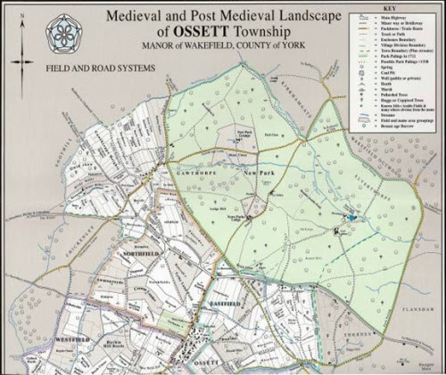
The Left map is taken from Richard Glover’s book “ Medieval and Post Medieval Landscape of Ossett Township” (2008). At bottom right it shows Haggs Hill in Thornes with Haggs Lane to the south traversing Lights Brig and along the High Road to Woodkirk and Leeds. The Key suggests the possibility that the New Park boundary (park palings) pre 1711 may have been the line of Haggs Lane.
All this points to the significance of the area in earlier times standing on important east to west and north to south trade routes. Not surprisingly therefore the housing that did exist in the area was built along these routes on Street Haggs, Haggs Lane and to the east on Teal Town Road (which derived its name from the many families named Teal(le) who lived there in the 19th century). Indeed until the mid 1960’s the few remaining dwellings which there were on Haggs Hill were located along Haggs Lane/Haggs Hill Road and there is evidence of dwellings along this route from much earlier times.
Haggs Hill Farm
Over the years much of the land comprising Haggs Hill has been farmland and so the history is dominated by that associated with Haggs Hill Farm, or Haggs Farm as it was once known.
In his Will, Robert Haigh (1696-1768), left his daughter Ann a moiety (half share) of all that Farm or Estate commonly called Street Haggs late in my possession but now in the occupation or possession of my son in law John Raynor. Robert Haigh is described as a Tanner of Street Haggs and elsewhere as being of Haggs and Ossett Lights suggesting that his land ownerships covered much of the area now known as Haggs Hill.
The 1774 Valuation Survey of Ossett & Gawthorpe records two fields, Pear Tree Close and Stoney Pighill in the ownership of John Raynor. These fields formed the part of Haggs Farm located in Ossett; the remainder being located just over the Alverthorpe with Thornes boundary. Further evidence of occupation is found in The Ossett Inclosure Order of 1813 which shows Haggs Farm as “now or lately belonging to Robert Raynor…and a plan in the Order shows Haggs Farm in the position now occupied by Haggs Hill Farm.
Robert Haigh may have come by Haggs Farm by inheritance from his parents. He was the son of James Haigh and Barbara Leeke of Horbury. James was the long serving Minister at Horbury St Peter’s Church and Barbara was of the very well connected Leeke family once of Horbury Hall. In the 1709 Manor Book both James Haigh and Thomas Leeke are recorded as freeholders of land in Horbury. The Leekes were related to the Grice and Savile families.
In 1571 a Commission was appointed by the Chancellor of the Duchy of Lancaster to determine who was responsible for the repair of Wakefield Dam. Henry Grice of Sandal was one of those Commissioners and his work, with two other Commissioner colleagues, was to “thoroughly view and peruse the court rolls remaining at the Queen’s Castle at Sandal”. Plainly Henry Grice was in a position of some influence.
At the Great Court Leet of The Manor of Wakefield held on 2nd October 1573 Henry Grice was elected Grave of Stanley. In 1591 Henry’s widowed daughter Elizabeth married George Savile, a widower and the grandson of Thomas Savile of Lupset, a member of the great family which had been settled at Thornhill for many years. In 1569 the Queen had called for subscriptions to repel an intended rising of Catholic Lords in the north. Amongst others, Henry Grice of Wakefield was ordered to provide a corselet, a pike, a harquebus with a bow and a sheaf of arrows.
The following reference is taken from the Wakefield Court Roll of 1608… “ Grice Hen, for a mess &certain lands called Street Haggs being copyhold for which he pays rent to Bailiff of Fee of Wakefield (not to grave of Horbury) 17s 10d”
In the latter half of the 16th Century, the daughter of Thomas Grice, Ann Grice of Sandal, had married Ralph Blacker of Blacker Hall and two of their children were to marry into the Leake and Thornes families. Robert Haigh’s mother was Barbara Leeke and of course the Thornes family have long land owning connections in the vicinity of Haggs Hill farm. Also, interestingly, the great grand-daughter of Ralph Blacker, Elizabeth, was to marry Henry Reyner who went on to rent Blacker Hall and of course the Raynor family occupied Haggs Hill in the second half of the 18th Century. Later there is reference to ownership of the farm by the Wheatley family who were related to the Haighs and in the 1843 Tithe Award Timothy Wheatley is described as a devisee of the estate of Joseph Thornes.
There is sufficient information in these references to suggest that by the 16th Century Haggs Hill was owned by the Saville family and that it may have passed down through the Grice and Blacker families to the Haighs and the Raynors. Other references, above, to Thornes, Lupset and Horbury reinforce the possibility that the Grice family once owned the land.. Neither were the Savilles strangers to landholdings in Ossett .The Saville branch that married into the Cardigan family had holdings on Ossett Common and in the New Park and as indicated above some local historians (1) believe that the Haggs Hill area may well have been a part of the Lord of the Manor’s hunting park – New Park – before the 18th century.
In any event it is probable that Robert Haigh and his wife Sarah Wilson lived on Haggs Hill in the first half of the 18th century and that they were followed by their daughter, Ann, and her husband John Raynor. The 1795 Poor Law record shows the first entry as “Mr Rayner” and other names in the book adjacent to Rayner suggest that the record may begin at the Ossett boundary with Alverthorpe With Thornes. By 1813 the Ossett Inclosure Order records Robert Raynor in occupation of Haggs Farm. By 1844 the ownership of Haggs Farm had changed again and on 24 April 1844 the Leeds Mercury carried the following Notice for the sale of lands in the possession of the Trustees of the Estate of Timothy Wheatley of Hopton.
In the Ossett Tithe Award 1843 Timothy Wheatley is recorded as a devisee of Joseph Thornes Execs in relation to 5 acres 0 roods 37 perches of land with the field names Pear Tree Close and Stoney Pighill. These fields were the part of Haggs Hill Farm which was, at that time, in Ossett. The remainder of the Farm was in Thornes and it was only in 1900 that the whole of the Farm came to be Timothy Wheatley (1776-1829) was a merchant and one of six children, all boys, from Hopton. He was to become the father of five children, all girls, two of whom pre-deceased him. Following his death at Thornhill Lees, perhaps at Lees Hall which was previously occupied by his grandfather, on 27th May 1829 his estate was managed by his executors and trustees until 1844 when his land and property were sold to realise value for distribution to his beneficiaries.
The Colliery mentioned in the Auction Notice could be Roundwood (which stood at Haggs Lane End) or, perhaps more likely, Wheatley’s Colliery shown below in the 1850 map. It is known that Charles Wheatley owned the Farm by 1847(Thornes Tithe Award) and it is likely he bought the Farm and the colliery from Timothy’s estate.The1850 map shows Haggs Hill House as a substantial, perhaps a grand, house but it is not known if Timothy, or any other of the Wheatleys, ever lived there.
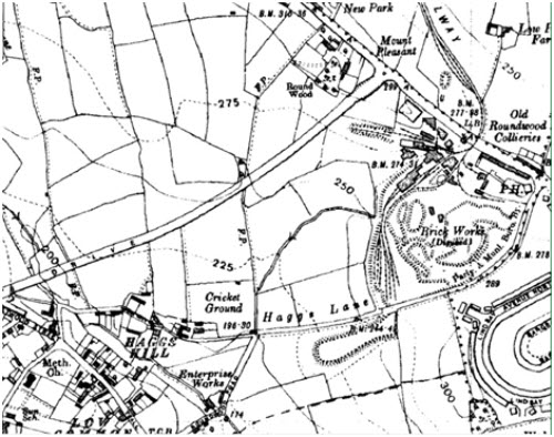
Haggs Hill in 1850
The Ordnance Survey map of 1850 shows Haggs Hill House in the south, the Wakefield & Halifax Turnpike Road and Upper Street in the north, Lights Bridge in the west and the Malt Shovel Public House in the east. This is Haggs Hill as it was known in earlier times. Haggs Lane runs east to west from Lights Bridge to the Malt Shovel. The Wakefield boundary line is shown running north/south adjacent to Haggs Hill House with Haggs Farm to the east of the boundary and to the west is a second farm between Haggs Hill House and Lights Bridge. Approximately 100 years later this farm, on the north side of Haggs Lane, was to be known as Queens Drive Dairy Farm. The 1850 configuration of buildings at Haggs Hill House is almost identical to that shown more than 100 years later in 1955.
In the north east corner of the map the New Park is shown to the north of the Turnpike Road and it is believed by some that before 1700 the Park boundary was Haggs Lane. Other features of the 1850 Haggs Hill landscape include industrial activity in the shape of collieries, engines and a brewery and brick works at Roundwood at Haggs Lane End. Dwellings existed at places along Haggs Lane and on Low Common to the west. It is also fairly clear from the 1850 map that the house which then stood where Haggs Hill Farm is today was one of some significance. It is described in the map as “Haggs Hill House”. This is not the late 19th/early 20th Century house which stands there today though the remains of the adjacent barn do appear to have 18th Century origins.
To the east of Haggs Hill House situated on Haggs Lane, is a Black Engine which is most probably a steam powered pumping mechanism used to pump water from mine workings. (The later 1890 map shows a shaft in this position – in today’s landscape this would be situated at the foot of the M1 embankment)
The 1847 Thornes Tithe Award records Charles Wheatley as the owner and occupier of the Farm holding. Charles Wheatley (1785-1849), was Timothy’s brother, and it would be him, or Charles’ son, also Charles (1813-1900) who purchased the farm, land and colliery from Timothy’s estate. Either way Charles Wheatley junior, of Sands House in Hopton Mirfield was the owner of the farm holding at the time of his death in 1900. Charles was a bachelor and, apart from several legacies and charitable distributions he left the remainder of his £500,000 (approximately £30m in current values) estate to his great niece Eleanor Steele. It appears likely that it was around this time that Haggs Hill House was demolished and a newer, less substantial house was built.This is the house which stands there in 2010.

Left: Jesse David Batley(III) at Haggs Hill Farm with Roundwood Colliery behind. Probably about 1930.
Between 1871 and 1901 Charles Wheatley let the Farm first to Robert Renshaw and later to his son John. Eleanor Steele continued to let the farm to tenant farmers and between 1901 and 1919 it was occupied by James Green and his wife Dinah, itinerant farmers and parents of seventeen children including three named Farewell, Harvest and Theresa Green. Following Eleanor Steele’s death in 1910 her estate was inherited by her children and much later in 1929 Haggs Hill Farm was sold by Eleanor’s son, Adam Rivers Steele, to Jesse David Batley. By this time the farm holding had been divided by the 1920’s built Queens Drive.
Jesse David Batley II was born in Saltaire in 1873. His father, also called Jesse David Batley I, worked for Titus Salt before becoming a confectioner at Boothroyd in Dewsbury. He later bought a small piece of land at the junction of Teal Town Road and Manor Road and by 1891 Jesse David Batley II was living here with his widowed mother, working the land, whilst also working at Roundwood Colliery as a coal hewer. In the 1920’s he moved to Haggs Hill Farm before buying it in1929.
Having bought the Farm in 1929 Jesse David Batley II set about making it work but by 1945 the Farm had become too much for him and his son (also Jesse David Batley III named after his father and grandfather) who lived on the nearby and newly constructed Queens Drive and in 1945 the 72 year old Jesse David II sold the land and property for £2000 to John Scholey Menmuir of West Ardsley who erected a substantial greenhouse on the land.
By the early 1950’s Mr Menmuir had sold the Farm to in two parts. Land to the south of Haggs Lane was sold to a Jack Scholefield and Millicent Collins in 1950. The remainder of Farm holding (now 16.5 acres) to the north of Haggs Lane was sold to the National Coal Board (NCB) in 1954 because the NCB had become tired of compensating the Menmuir family for the damage to their crops caused by burning pit waste at the adjacent Roundwood Colliery. By all accounts it turned the Greenhouse lettuce blue.
From thereon the NCB held the freehold of the Farm and rented to tenants. For most of the next 35 years Jeffrey Gill Wilby, was farm tenant until his death at the Farm in 1990. In Summer 1992 the NCB accepted a reported offer of £108,000 for the Farm and the associated land, approximately 9 acres to the south of Queens Drive. The remaining 4.4 acres or so of the Farm to the north of Queens Drive was retained by the NCB in the hope that a planning consent might be obtained for alternative use. When this failed they sold the land in the late 1990’s to a property company who currently (2010) rent the land. The remainder of Haggs Hill Farm, to the south of Queens Drive remains in the hands of the owners who purchased it in 1992.
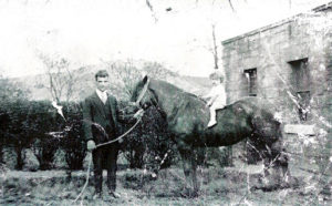
Left: David Batley (son of Jesse David Batley III) at Haggs Hill Farm with Roundwood in background.

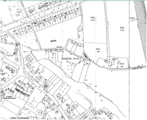
The earliest map of the Haggs Hill area was made in 1850 and shows housing development along Haggs Lane. It is known that there were dwellings at Haggs Lane End near Roundwood Colliery and also along the Wakefield & Halifax Turnpike Road at Shepherds Hill and Upper Street Side. On the broadest definition of the area these localities have been described as Haggs or Street Haggs but here reference is only made to those dwellings built within the curtilage of Haggs Hill Farm and to those houses built to the west of the Farm along Haggs Lane towards Low Common. An examination of the 1850 and 1955 maps reveals few differences in housing provision over 100 years.
In 1844, when Timothy Wheatley’s Trustees were selling the Farm the Auction Notice indicated that in addition to the Farm homestead there were ten cottages or dwelling houses for sale and these were occupied by “Thomas Grace, William Hetherington, George Oakes and others”. To see the precise layout of these houses at the Farm, and others on Haggs Lane a map of 1955 is reproduced above. The 1850 and 1955 maps reveals few differences in housing provision over 100 years but where there were 10 cottages within the curtilage of the Farm in 1850 there are only eight in 1955. Noteworthy too is the large greenhouse built on the land in front of the Farm house.
The 1955 map records postal addresses as at that time. Reading from left to right (west to east) the first properties shown are numbers 7 and 9 Haggs Hill Road. These are 18th Century cottages built in the 1780’s by Joshua Haigh and occupied by the Pickard family. An earlier property probably stood here before 1780.The cottages still stand here in 2010 and their history is recorded elsewhere. Numbers 1, 3 and 5 stood to the left of 7 and 9 Haggs Hill Road (where now stand two council bungalows and a 1980’s house). Before their demolition between 1950/1955 the three dwellings, 18th Century cottages, were once owned by John Dickinson (1807) and Francis (Frank) Nettleton (1918). These dwellings only had a Haggs Hill Road address from 1901; prior to this their address was Low Common and later, South Parade because Teal Street stopped where it met South Parade and was only extended to meet Queens drive in the 1920s.
Odd number postal addresses continue to the north of Haggs Hill Road with number 11 (formerly Queens Drive Dairy Farm once owned by Wally Gill and later by Percy Wilby. Number 11 is now a detached house built in the early 1970s. To the east of the original number 11 was a terrace of three cottages numbered 13, 15 and 17. These stood opposite the present number 44 (“Cosy Cottage”) Haggs Hill Road and were demolished between 1970 and 1972.
The remaining dwellings to the east are within the curtilage of the Farm and comprise eight of the ten cottages included in the Sale Notice of 1844 and it seems likely that two of these were demolished or collapsed before 1871. These eight cottages comprise the following. A row of three cottages (numbers 19 [3 rooms],21[2 rooms] and 23), at right angles to Haggs Hill Road. Further east is number 25, now Haggs Hill Farm House[5 rooms], and numbers 27[5 rooms] and 29[4 rooms] which were attached to the eastern gable of the farmhouse. In the front of the farmhouse stood three cottages, numbers 31[2 rooms],33[3 rooms] and 35[2 rooms]. All but number 25, the house which still stands at Haggs Hill Farm, were demolished between 1957 and 1966.
Dwellings with even numbers were to the south of Haggs Hill Road and working right to left (east to west) the first is number 16 [which had 2 rooms and became number 46 in 1960s]. This site appears to have had a chequered history, the land being subject to a statutory declaration in 1918.This house no longer exists and in its place stands a garage in the grounds of the current number 44. Next door, to the west stands the four-roomed number 14 (“Cosy Cottage – rebuilt in the 1970’s – and now number 44). To the west of this house is number 12, also with four rooms (until 2007 it was number 42) once the home of Watson Hirst, which stood in ¾ of an acre of land and was bought by Percy Wilby in 1960 after he sold Queens Drive Dairy Farm. It is now the site of seven houses built in 2007 and known as Rushmead Court (these new houses carry the addresses of 67 and 67a Teall Court, 42 Haggs Hill Road and 1-4 Rushmead Court). Further west stood a row of three cottages numbers 8 [3 rooms], 10 [3 rooms] and, oddly, 10a [28, 30 and 32 in 1960s] suggesting that numbers 8 and 10 were built earlier than 10a, which appears from the map to be detached from 8 and 10 (which shared a privy). Numbers 8 and 10 were bought and sold by Percy Wilby in the 1950’s These would be demolished between 1966 and 1970.
Slightly to the west was another terrace of three cottages numbers 2 [4 rooms],4 and 6 [2 rooms].These became numbers 22, 24 and 26 Haggs Hill Road in the 1960s. These too would be demolished in 1971. The addresses of the houses to the south of Haggs Hill Road appears to have changed in the 1960s. This was probably as a result of the construction of three pairs of bungalows at the Teall Street junction with Haggs Hill Road on land allotted to Joshua Haigh in 1807 and sold by David Pickard Harrop in about 1960. The addresses of these bungalows are 2, 4, 6, 8, 10 and 12. In the 1960s the next addresses along Haggs Hill Road were 22 to 32 and .then 42 to 46. When the properties were re-numbered, numbers 14 to 20 and 34 to 40 were omitted. Perhaps it was to accommodate other development proposals which never came to fruition, or perhaps the intention was that some of the Teall Court houses would carry a Haggs Hill Road address.
Of the houses on Haggs Hill in 1850, only two have remained undiminished by subsequent development and change. These are numbers 7 and 9 Haggs Hill Road known as “The Cottages” and the history of these dwellings is recorded elsewhere. Having established the location of dwellings on Haggs Hill Road from 1850 onwards the following analysis identifies the people who lived here. The section records the families who lived in the ten dwellings (eight after 1861) at Haggs Hill Farm and the second section looks at the families who lived elsewhere on Haggs Lane.
Haggs Hill dwellings
The Auction Sale Notice of 1844 records 10 cottages for sale in addition to the Farm homestead. After 1861 it appears that the number of dwellings has fallen to nine including the Farm House. The layout of the dwellings within the Farm holding is shown in the above 1955 map. It seems likely that the two demolished or collapsed dwellings were once attached to numbers 19,21 and 23 to make a terrace of five dwellings. Elsewhere on Haggs Hill 13 dwellings were constructed along the line of Haggs Lane between Haggs Hill Farm in the east and Low Common in the west. 9 of these were on the south side of the Lane and only 4, including Queens Drive Dairy farm, to the north. It is not known for certain when these houses were built though it seems likely that most were here by the 1860’s and they survived until the 1960’s and this suggests:
The census records reveal the following:
The 1841 Census records 19 dwellings:
In the 10 Haggs Hill Farm Cottages:
Thomas Grace and William Hetherington (as they were at the time of the 1844 Auction Sale) William Grace, Thomas Page, Robert Howgate, Jos Wild, John Wilcock, James Ward, Thos Butterfield, Charlotte Wilby, William Tresh and Joseph Gower. There are 13 families here suggesting some were living elsewhere on Haggs Lane. Eight of the 13 families were miners. One was a blacksmith.
To the west of the Farm only 4 dwellings appear to exist:
Aaron Brummit (Brickmaker), Joshua Wilby (Boat owner!), and Nathan Brummit are shown living on the south side of the road. Only David Fothergill appears to be living to the north of Haggs Hill Road and probably working the Dairy Farm.
In the 5 cottages 1-9 Haggs Hill Road (with a Low Common address)
Joseph Pickard, Hannah Pickard, Mark Pickard, Robert Pickard, David Teale,. All were clothiers, most probably journeymen with their families working handlooms in the upstairs rooms.
In 1851:
In the Haggs Hill Farm Cottages (9)
George Oakes (Banksman), Thomas Grace (Miner), Joseph Ward (Miner), Charles Pollard (Blacksmith), James Archer (Farm Labourer), James Ward (Miner), Thomas Page (Miner), William Dougle (Miner) and Joshua Swallow (Miner). This suggests nine dwellings and seven of the families were engaged in coal mining. One was a blacksmith. Elsewhere on Haggs Hill:
To the west of the Farm (5)
the census has only Aaron Brummit (Clothier), William Hetherington (Carrier) and Mary Naylor (widow) living on the south side of the Lane. I suspect they were living in the detached cottages and that the terrace of three cottages occupied in later years had not been built until after 1851. Only Charles Hetherington and George Wilson are shown living on the north side.
In the (5) cottages 1-9 Haggs Hill Road (with a Low Common address)
Martha Pickard, Joseph Pickard, David Pickard, Robert Pickard, Isaac Pickard. All were weavers/spinners except Isaac who was a dealer in malt, flour etc.
In 1861:
In the Haggs Hill Farm Cottages(10)
Ten families are living at the Farm cottages. William Dews (Miner)/Martha Scott (Burler), William Allsop (Agricultural Labourer), George Oakes (Book keeper), Thomas Grayson (Carter), Thomas Nightingale (Nail Manufacturer), George Alderson(Carpet Weaver),George Ramsden (Retired Miner), Harris Brown (Agricultural Labourer) and Nathan Brummit (Weaver). This suggests ten dwellings and the occupations of those living here in 1861 were significantly different to the mining presence some ten years earlier. Most of the cottages here were owned by the Wheatley family and it is probable that they were built to house miners working at Wheatley’s nearby Colliery. This closed, probably in the mid 1850’s and even though the nearby Roundwood Colliery was still working it seems likely that the change in the nature of the occupations of the Haggs Hill households was due to the closure of their landlord’s Colliery.
To the west of the Farm (7)
John Teale (Weaver) Aaron Brummit (weaver) Joshua Wilby (Retired Farmer) Amos Teale (Weaver) and William Bould (Weaver) were living on the south side and only James Durkin (Agricultural labourer) and George Wilson are shown living on the north side of Haggs Hill Road. The terrace shown on later maps on the north side of the road appears not to be shown in the 1854 map.
In the (5) cottages 1-9 Haggs Hill Road (with a Low Common address)
Mark Pickard, Joseph Pickard, Lydia Pickard, Robert Pickard, Isaac Pickard. All were weavers.
In 1871:
In the Haggs Hill Farm Cottages(8);
Joseph Ramsden (Labourer), George Oakes (Coal Agent), William Allsop(Farm Labourer), Robert Pickard (Coal Miner), Thomas Crowther(Coal Miner), Edward Hudson (Coal Miner), Matthew Brummit (Clothier) and William Binns (Dyer).
To the west of the Farm (9)
Rowland Teale(locomotive Engine driver), Aaron Brummit (Weaver) James Longley(Cloth Weaver) William Oakes(Engine Driver) and Henry Green(miner) To the north side were Emma Child and William Healey. George Wilson and Eliza Fothergill are also shown and they were probably living at the Dairy Farm.
In the (5) cottages 1-9 Haggs Hill Road (with a Low Common address)
Benjamin Fothergill (Weaver), John Dews (Engineer), Joshua Redfearn (Flock Grinder), Isaac Pickard (Weaver), Enoch Pickard (Weaver)
In 1881:
In the Haggs Hill Farm Cottages(7)
Henry Dyson (Engine Wright), William Allsop(Farm Labourer), John Allsop (Carpet weaver),Walter Morton (Labourer at Iron works), George Hill Driver (Railway Plate Layer), William Renshaw (Labourer Farm), Fred Nettleton (Engine Fitter).
To the west of the Farm (12)
In 1881 the south side of Haggs Hill Road shows Rowland Teall (Engine Fitter Coal), Aaron Brummit (Gardener aged 80), Henry Matthews (Miner), Maria Sykes (widow) and Ann Green. The analysis shows only five residents suggesting that one of the terraces of three cottages was built after March 1881 and before March 1891. On the north side were Emma Child, Abraham Crossley, Walter Lightowler, Job Child, Amos Etherington and Alice Sampson. This shows six families where the map suggests there were homes for only three. It is possible that some shown on the north side of the road were living on the south. Eliza Fothergill is also shown but she was probably living at the Dairy Farm.
In the (5) cottages 1-9 Haggs Hill Road (with a South Parade address)
Unoccupied, George Hepworth (Plumber), Oliver Illingworth (Shopman), Isaac Pickard (Cow Keeper), Ellen Harrop (widow).
In 1891:
In the Haggs Hill Farm Cottages(7)
Occupied by Alfred Killbourn (Colliery Clerk), Wright Oakes (Blacksmith), Arthur Chappell (Coal Miner), Joseph Wilby (Coal Miner), Mary Reynolds (widow), Richard Reynolds (Coal Miner) and George Lodge (Coal Miner).
To the west of the Farm (12)
George Renshaw (miner), Owen Naylor(Rag Grinder),William Hallas (Miner), Sydney Ramsden( Miner), Joseph Ramsden(Miner), Henry Jackson (Farm Labourer), Samuel Richmond (General Labourer) and Ann Fothergill (living on own means). On the north side of Haggs Hill Road lived Emma Child (widow), Charles Asquith (Banksman), John Harrison(Tailor) and George Webster (Miner). The census also shows a George Stevens who may have been living at the Dairy Farm.
In the (5) cottages 1-9 Haggs Hill Road ((with a South Parade address)
Joseph Williamson in 3 roomed home (Carpet Designer),Thomas Hewitt in 2 roomed home (Wool Extractor), Hannah Dews in 4 roomed home (Widow), Isaac Pickard (Farmer), Unoccupied. Thomas and Margaret Hewitt had 8 children aged 1 year to 17 years old. The family were living in a two roomed home.
In 1901:
In the Haggs Hill Farm Cottages(7)
The seven Farm cottages were occupied by Alfred Kilburn (Colliery Weighman), Thomas Glover (Circular Sawyer), Isaac Hetherington (Coal Hewer), George Harrop (Coal Miner), Joseph Wilby (Colliery Labourer), Joe Stephenson (Coal Miner) and Arnold Blakely (Blacksmith).
The 1891 and 1901 Census reveals a re-emergence in the number of households once again working the local Colliery, which almost certainly this would be Roundwood. There is evidence that in 1900 Frank Nettleton was renting the 7 cottages and the Farm House from Charles Wheatley who was still the owner. Francis or Frank Nettleton was the Roundwood Colliery manager, himself living at nearby Mount Pleasant (at the top of Queens Drive). Frank Nettleton would be subletting the cottages to Roundwood miners.
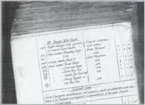
Above: Schedule from Charles Wheatley’s Will of 1900 in the Wakefield Court Rolls.
To the west of the Farm (13)
In 1901 the families living on the south side of Haggs Hill Road included Reuben Peace (living on his own means), Samuel Richmond (Gardener), Peter Blackburn (Coal Hewer), Joseph Kilburn (Coal Hewer), Ralph Crossland (Carpenter), Benjamin Teale (Colliery Railwayman) and Margaret Renshaw (widow). One of the cottages was empty. On the north side of Haggs Hill Road lived Emma Child (widow), Charles Asquith (Banksman), John Harrison(Tailor) and George Webster (Miner). The census also shows a George Stevens who may have been living at the Dairy Farm.
In the (5) cottages 1-9 Haggs Hill Road (with a Haggs Hill Road address)
Friend Dews [3 rooms] (Coal Hewer), Thomas Hewitt [2 rooms] (Carter), Isaac Marsden [4 rooms](Coal Hewer), Joseph Summerscale [3 rooms] (Miner Colliery Deputy), Isaac Pickard [4rooms] (Market Gardener).
1911 Census:
In the Haggs Hill Farm Cottages(8)
Alfred Pashley [no. 19 Haggs Hill; 3 rooms](Coal Hewer)
Joe Stephenson [no.21; 2 rooms] (Hewer)
Joshua Wilby [no. 23; 2 rooms] (Colliery Labourer)
Sarah Kilburn [no.27; 5 rooms](widow)
Lister Child [no. 29; 4 rooms] (Colliery Official)
George Harrop [no.31; 2 rooms](Hewer)
Isaac Hetherington [no.33; 3 rooms] (at Home)
Thomas Glover [no. 35; 2 rooms] (Wood Sawyer)
Worthy of note is that in 1911 Joe Stephenson and his wife had eight children, all girls, and they lived in 2 rooms. Thomas Glover and his wife had three surviving children from 12 born to the couple.
To the west of the Farm (13)
South of Haggs Hill Road;
Lewis Shires no.2. 4 rooms Jobbing gardener
Unoccupied no.4. 2 rooms
Herbert Holmes no.6 . 2 rooms Coal Getter. 4 children (2 boys; 2 girls) The house has one bedroom.
Margaret Renshaw no.8. 3 rooms Widow
Thomas William Dews no.10 3 rooms Hewer
Peter Marsden no.12. 4 rooms Coal hewer (of 8 children to the couple only 2 survived to 1911)
S F Richmond no.14. 4 rooms (recorded as 2 rooms in 1901) Nurseryman
Reuben Peace no.16. 2 rooms Gentleman
North of Haggs Hill Road
Joshua Illingworth Morton no.11. 5 rooms Farmer. This is the dairy farm.
Fred Grace no.13. 2 rooms Miner Deputy
Walter Merryweather no 15. 2 rooms Hewer
Ben Garside no. 17. 2 rooms Teamer.
In the (5) cottages 1-9 Haggs Hill Road (with a Haggs Hill Road address)
Isaac Marsden [no. 1 Haggs Hill Road; 4 rooms] (Dealer in old iron)
Margaret Hewitt [no. 3; 2 rooms](widow)
Friend Dews [no5 Haggs Hill Road; 3 rooms]
James Thompson [no.7; 3 rooms](miner)
Isaac Pickard [no. 9; 4 rooms] (Market Gardener)